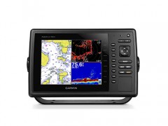
| Negara Asal: | Taiwan |
|---|
Physical & Performance
Unit dimensions, WxHxD 11.5 " x 7.4 " x 2.9 " ( 29.3 x 18.8 x 7.4 cm)
Display size, WxH 6.4 " x 4.8 " ; 8.0 " diagonal
( 16.2 x 12.1 cm; 20.3 cm diagonal)
Display resolution, WxH 800 x 600 pixels
Display type SVGA display
Weight 3.5 lbs ( 1.6 kg)
Waterproof Yes ( IPX7)
Receiver 10 Hz high-sensitivity
Antenna with external connection
Mounting options Bail, flat or flush
Power consumption Max power usage at 10 Vdc: 14 W
Typical current draw at 12 Vdc: 1.1 A
Max current draw at 12 Vdc: 3.2 A
Maps & Memory
Preloaded maps None
Accepts data cards 2 SD cards
Waypoints 12, 000
Routes 200
Track log 25, 000 points; 100 saved tracks
Features & Benefits
Garmin Radar compatible Yes
Garmin Sonar compatible Yes ( built-in) and GCV black box compatible
NMEA 2000 compatible No
NMEA 0183 compatible Yes
Garmin Marine Network compatible Yes ( limited capabilities)
Garmin SmartMode compatible ( customizable monitor presets) No
Supports AIS ( tracks target ships position) Yes
Supports DSC ( displays position data from DSC-capable VHF radio) Yes
Tide tables Yes
Garmin Meteor Audio System compatible No
Supports Fusion Lync compatible marine radios No
GSD Black Box sonar support No
GCV Black Box sonar support Yes
SiriusXM Weather & Radio compatible No
BlueChart Mobile ( planning) compatible No
Garmin Helm compatible No
GRID ( Garmin Remote Input Device) compatible No
Wireless remote compatible No
Wireless mouse compatible No
Sonar Features & Specifications
Dual-frequency ( 50/ 200 kHz) sonar capable Yes
Dual-beam ( 77/ 200 kHz) sonar capable Yes
Frequencies supported 50/ 77/ 200 kHz, CHIRP ( low, medium, high) , DownV
Transmit power 1 kW traditional; 600 W CHIRP
CHIRP sonar technology Yes ( Built-in)
DownV Yes with CHIRP ( built-in)
SideV Yes ( with GCV black box, sold separately)
Voltage range 10-32 Vdc input
Maximum depth 1, 750 ft @ 50 kHz, saltwater, Garmin dual freq transducer @ 500 W
2, 700 ft @ 50 kHz, saltwater, Airmar B260 transducer @ 1000 W
( depth capacity is dependent on water bottom type and other water conditions)
Bottom lock ( shows return from the bottom up) Yes
Water temperature log and graph Yes
Sonar recording Yes
Sonar history rewind No
Connections
NMEA 0183 input ports 2
NMEA 0183 output ports 2
Video input ports None
Video output ports None
Wireless connectivity No
Garmin Marine Network ports 1
Nusatama Store
GPS,Alat Survey,Alat Geologi,Telepon Satelit, Perahu Karet
Jl.H.Sapri No.32 Pondok Aren
Tangerang Selatan - 15224
Telepon : 021-83943215
Sales : Ambar
Hp : 0812-8985-4242 / 0817-675-5161
Pin BB : 277F253D
www.nusatamastore.com


